Tuesday, October 18, 2011

Annapurna Conservation Area


The Annapurna conservation Area is one of the best trekking trails in the world. The area spreads around Kaski, Mustang, Manang, and Lamjung districts of Central Nepal. Starting with an altitude of 790 m, the area reaches as high as 8,091 m of mt. Annapurna. Ghandruk is the first experience and further down is Ghorepani that provides fantastic panoramic view of the Annapurna ranges. Equally eye catching area hills of rhododendron that blossom every spring. The turning point of the Annapurna Circuit is Jomsom. The trek southeast from Jomsom, leads to the scenic Tilicho Lake area at an altitude of 4,919 m. In the circuit route, is the famous Hindu religious sites Muktinath Temple. The vegetation in this region includes various species of orchids and rhododendron. Wildlife includes 102 different kinds of mammals including rare endangered snow leopard and a very good population of blue sheep. The region also boasts of around 474 species of birds including multi-colored impheyan, koklas and blood pheasants. In addition the region is also home to 39 species of reptiles and 22 species of amphibians.  

Wednesday, September 28, 2011

Shivapuri Nagarjun National Park


Leopard
Shivapuri Nagarjun National Park is popular as trekking, hiking and recreation area, the Park offers the nearest retreat from Kathmandu. The park was established as a Watershed and Wildlife Reserve in 1976 and was declared as a national park in 2002 for the protection of its flora and fauna. Vegetation varieties in the park include its 129 species of mushrooms while animals include 19 species of mammals including Himalayan black bear, leopard, barking deer, wild boar, wildcat, rhesus monkey and langur monkey. The park also boasts of 177 species of birds and 102 species of butterflies.

The Parsa Wildlife Reserve


The Parsa Wildlife Reserve spreads over parts of Chitwan, Makawanpur, Parsa and Bara districts. The vegetation is tropical and sub tropical mostly covered with Sal forest, while the hills are covered with chir pine. Khair, Sissoo and Silcotton are found along water areas. The reserve provides good habitat for animals like wild elephant, tiger, leopard, sloth bear, gaur, blue bull and wild dog. Other common animals in the reserve are sambar, chital, hug deer, barking deer, langur monkey, rhesus macaques, striped hyena, rat,   palm civet and jungle cat. There are 370 species of birds found in the reserve, one being the endangered great hornbill found in certain parts of the forest. Other bird species include peafowl, red jungle fowl, flycatchers and woodpeckers. Apart from birds and animals the reserve is also habitation by snakes like king cobra, common cobra, krait, rat snake and python.

Tuesday, September 27, 2011

Koshi Tappu wildlife Reserve


Koshi Tappu wildlife Reserve has carved a place for itself as a bird watcher’s paradise. The reserve spreads over Saptari and Sunsari districts in East Nepal over the embankments of Rivers Koshi. The reserve has been recognized as a Wetland Site from 1987. The vegetation of the reserve is mainly grassland with patches of scrub and deciduous riverine forest. The reserve has recorded around 479 species of bird variety, some of which fly all the way from Siberia during winter. A wide variety of ducks, herons, storks, egrets, ibis are seen on the riverbanks. Koshi Tappu wildlife reserve also has one of the few elephant stables of Asia. Other animals found here are wild buffalo, wild boar, hog deer, spotted deer, blue bull and jackal. Gharial crocodile and Gangetic dolphin are also found here.

Monday, September 26, 2011

LANGTANG NATIONAL PARKS


It was established in 1976 to conserve the unique flora and fauna of the region. It is the nearest natioanal Park of the capital Kathmandu in the Central Himalayan Region. The 1710 sq. km. of the park extends over parts of Nuwakot, Rasuwa, and Sindhupalchok districts in the southern mountainous terrain of the Nepal-China (Tibet) border. In 1998 an areas of 420 km2 in and around the park declare as a buffer zone. The park represents a meeting point between indo-Malayan and Palearctic realms, and holds a rich biodiversity.
Buffer zone management is a joint venture between the park office and the local communities. Local communities have a decision-making role in the management of such areas. Additionally, the local communities or the BZ receive 30 to 50 % of the park revenue for the better management of natural resources to ensure a sustainable supply of resources and community development

Climate
September through May offers a variety of natural splendors, from lush temperate river valleys with screeching langur to spectacular old growth forest and glacial-craved cliffs rimmed by snow-covered peaks. The weather is also relatively dry except January-February when one may come across snow.Autumn is the best time to visit the park. By April bursts of red, pink, and while rhododendrons stretch into towering canopies of fir and oak forests. Advent of warm weather makes the Yak and Chauri herds ascend to higher elevation, making occasional camps in the pasturelands, to follow years of tradition. From June to august, skies are heavy with monsoon rains. During August, a lively festival at Gosaikunda Lake attracts thousands of Hindu pilgrims and September witnesses’ spectacular display of wild flowers, while livestock herds, once again, return to lower pastures

Shey-phoksundo National park


Shey-phoksundo National park is situated in the Trans-Himalyan region of north-west Nepal. It is Nepal’s largest national park. With diverse terrain and altitude veriation, the park spreads over Dolpa and Mugu districts and supports a broad range of wildife and vegetation. Geographical landmarks of the park are the Himalayan Peaks in the north and Lake Phoksundo, in the southern region. Vegetation includes pine, walnut, willow, oak, and cypress in the lower altitude and pine, spruce, juniper and birch at higher regions. Berberis, wild rose and caragana are seen in alpine areas while the regions higher up are mostly arid with grass alpine meadows with barely any trees. The park contains 286 flora species of botanical importance. Animals found in the region are sheep, ghoral, musk deer, leopard, wild dog, marmot, weasel, mouse hare, rhesus and langur monkeys, Himalyan tahr, Himalyan black bear and jackals. In the upper region is seen the rare and endangered snow leopard. Over 200 species including yellow-throated marten, Tibetan partidge, wood snipe, whitethroated tit, wood accentor, and crimson-eared rose finch are found in the park. Other species of birds found here are lmpeyan, cheer pheasant, chough, ravens, Tibetan snow cock, Tibetan twit, brown dipper, Himalyan griffon and lammergyer. Apart from these, the park is home to 6 species of reptiles and 29 species of butterfly.

Saturday, September 24, 2011

Dhaulagiri (8,167m): The seventh highest mountain in the world.


The Dhaulagiri massif lies northwest of Pokhara and climbing this mountain was at first considered impossible. It looked formidable and the French expedition that came to Nepal in 1950 and successfully climbed Annapurna I, didn’t even give this peak a second thought. Captain William ebb who came in 1809 was the first European to set eyes on Mt. Dhaulagiri. When he calibrated the height of the mountain, he was amazed. Up until then, the Andes in South America were considered the highest chain of mountains in the world. The news of this new discovery left the rest of the world incredulous. For many years since the revelation, Dhaulagiri was thought to be the highest mountain in the world.

“The White Mountain” as it was known to foreigners, was one of the peaks that could not be conquered during the Golden Decade. Although numerous attempts were made throughout the 1950s, none were successful. A string of expeditions arrived in Nepal: the Argentinians tried their luck in 1954. A Swiss- German team gave it a shot in 1955, and were followed by the Argentinians making a bid in 1956 once again, but with no better luck. In 1958, the Swiss were back and returned yet again without reaching the summit. Then it was the turn of the Austrians who could go no further than 7,802m.

In 1960, another Swiss expedition arrived in Nepal led by Max Eiselin and the team included Kurt Diemberger and Norman Dyhrenfurth who went on to earn a name for themselves. They brought along a Pilatus Porter named ‘Yeti’ which was piloted by Ernst Saxer for making drops on the French Pass up in the mountain. The expedition met with countless problems and was compounded by the crash of the Yeti. The pilot and repairman luckily escaped unhurt and walked all the way back to Pokhara from the mountain. But the expedition persevered and 13th May 1960 proved to be a lucky day for the mountaineers as it was a bright sunny day with practically no wind blowing. Six members of the expedition reached the summit to become the first to climb Dhaulagiri. They were Kurt Diemberger, Nawang Dorjee Sherpa, Ernst Forrer, Albin Schelbert, Peter Diener and Nima Dorjee Sherpa. Ten days later, Jugo Weber and Michel Vaucher followed in their footsteps and made it to the top. Nawang Dorjee became the first Nepali to climb the peak.

The numbers were amazing on this climb, 13 members set off to climb the mountain, summitted on the 13th and it happened to be the 13 eight-thousander to be climbed. No bad luck there.

Thursday, September 22, 2011

Cho Oyu (8201m): The sixth highest mountain in the world

Mt. Cho Oyu

Unlike other attempts, the successful expedition to Cho Oyu had its origins in very simple circumstances. Austrian climber, Herbert Tichy along with sherpas Adjiba and Pasang were gathered around a campfire on a mountain and enjoying fried liver, when Pasang suddenly asked, “Next year, Cho Oyu?” Tichy could only nod and repeat, “Cho Oyu”. Thus it was decided that the mountain would be attempted in 1954. In the previous years, Everest, Nanga Parbat and Annapurna among the other eight-thousanders. had been climbed.
Cho Oyu lies 20 km west of Everest, at the border between China and Nepal. In Tibetan, Cho Oyu means “Turquoise Goddess”. The first attempt on this mountain was made by an expedition supported by the Joint Himalayan Committee of Great Britain as preparation for an attempt on Mount Everest the following year. With Eric Shipton as team leader, the expediton also included Edmund Hillary, George Lowe, Charles Evans and Tom Bourdilon, but technical difficulties at an ice cliff above 6,650m forced them to give up the climb. It was estimated that it would take two weeks to get everyone across and it would also mean entering Tibetan territory which it is believed Shipton was unwilling to do.
It was Dyhrenfurth and Shipton who first came up with measurements that put Cho Oyu sixth on the list of the highest mountains in the world.
The Austrian expedition led by Herbert Tichy arrived in Birgunj in 1954 via India and flew into Kathmandu by means of an Indian airliner of the time. Once they were packed and ready, they moved to Bhaktapur from where the long trek  to the mountain would begin. Tenzing and Hillary had also begun their trek to Everest from this old city. As every expedition has its peculiarities, this one was no exception. There were only three foreign climbers and eleven Sherpa on the team.
Cho Oyu was finally climbed on 19th October 1954 via the northwest ridge by Tichy, Joseph Jöchler and Pasang Dawa Lama. Where as Shipton and team had been stopped by an ice cliff high on the mountain, the Austrians were able to tackle the problem in an hour and head up towards the summit. Pasang’s casual remark had led to a successful expedition. This was the fifth eight-thousander to have been climbed. Cho Oyu is considered the easiest to climb among the eight-thousanders and is also one of the most popular. The first Nepali national to climb the peak was Ang Phuri Sherpa on 29th April 1987.

Makalu (8,463m): The fifth highest mountain in the world


Mt. Makalu
     Mt.Makalu is 20 km east of Everest in the Khumbu region and is the fifth highest moutain in the world. The mountain lies in the Makalu Barun National Park and is known for its perfect pyramid shape with four sharp ridges. North of the mountain lies Tibet and it has two notable subsidiary peaks. Kangchungtse, or Makalu II, 7,678 m lies north-northwest of the main summit. The other is Chomo Lonzo which lies just north of the main peak. The first attempt on Makalu was made by an American team led by William Siri in the spring of 1954. They attempted the southeast ridge but were turned back at 7,100 m by a constant barrage of storms. In the fall of 1954, a French reconnaissance expedition made the first ascent of the subsidiary summit.

Kangchungtse on 22nd October. They were Jean Franco, Gyaltsen Norbu and Pa Norbu.
 Makalu was first climbed on 15th May 1955 by Lionel Terray and Jean Couzy, members of a French Expedition led by Jean Franco. The very next day, Franco, G. agnone and yaltsen Norbu also summitted followed by Bouvier, S. Coupe, Leroux and A. Vialatte on the 17th. The expedition climbed from the north face and northeast ridge via the saddle between Makalu and Kangchungtse which subsequently became the standard route.
The first ascent of the southeast ridge was made by Y. Ozaki and A. Tanaka from a Japanese expedition on 23rd May 1970. An American team had tried before them and ailed. The very technical West Pillar route was climbed in May 1971 by Frenchmen B. Mellet and Y. Seigneur. Makalu is one of the harder eight-thousanders and is considered one of the most difficult mountains in the world to climb. The mountain has challenging steep pitches and knife while the final ascent of the summit pyramid involves technical rock climbing. In 2006, a French mountaineer named Jean-Christophe Lafailee disappeared on Makalu while trying to make the first winter ascent. This mountain is the only Nepalese 8,000 m peak which has yet to be climbed in true winter conditions. The first Nepali to climb Makalu was Ang Chepal Sherpa on 1st May 1978. Note: Most of the Sherpa who climbed with the expeditions in the 1950s were considered Indian nationals as they had been living in India.

Lhotse (8,516m) The fourth highest mountain in the world


      Mt. Lhotse is connected to Everest via the South Col and is the fourth highest mountain in the world. The main summit is 8,516 m while Lhotse Middle (East) is 8,414 metres and Lhotse Shar is 8,383 metres. Very often, climbers making an attempt on Everest, go up the Lhotse to acclimatize. In fact, the usual route leading to Everest starts up the northwest face of Lhotse and then cuts across to the more famous mountain. An early attempt on Lhotse was made by the 1955 International Himalayan Expedition. It was led by Norman Dyhrenfurth and also included two Austrians, Erwin Schneider and Ernst Senn as well as two Swiss climbers, Bruno Spirig and Arthur Spöhel. It was also the first expedition in the Everest area to include Americans: Fred Beckey, George Bell, and Richard Mc Gowan. 
         They climbed up the West Cwm and the northwest face of Lhotse reaching an altitude of 8,100 metres. They were beaten back by unexpectedly strong wind and cold temperatures.
Working under cartographer Schneider’s direction, they completed the first map of the Everest area. They also made several short films on local cultural topics. Besides trying to summit Lhotse, the expedition also made a number of first ascents of smaller peaks in the Khumbu region.
On this mountain, it was the Swiss who were victorious. Victorious—because in the 1950s, there was much competition between nations to summit a virgin peak before the others. On 18th May 1956, a Swiss team of Ernst Reiss and Fritz Luchsinger from the Swiss Mount Everest/Lhotse Expedition reached the summit becoming the first climbers to do so. Lhotse Shar was summitted on 12th May by Zepp Maier and Rolf Walter of Austria. It was some time before Lhotse Middle was climbed, and for many years remained the highest unclimbed, named point on Earth. It was only on 23rd May 2001, that members of a Russian expedition made it to the top of this peak. The victorious team members were Eugeny Vinogradsky, Sergei Timofeev, Alexei Bolotov and Petr Kuznetsov. The first winter ascent on Lhotse was made by a Polish climber named Krzysztof Wielicki on 31st December 1988 and the first Nepali to climb it was Urkien Tshering Sherpa on 8th May 1977.

Kanchenjunga (8,586m): The third highest mountain in the world


       There was a time when Mt. Kanchenjunga was considered the highest mountain in the world. This as before the startling discovery made by the Chief Computer (today they are replaced by machines) who pointed out that Peak XV was in fact higher than Peak IX, Kanchenjunga. Later it became apparent that Peak IX was actually only the third highest mountain after Everest and K2 (Karakoram,
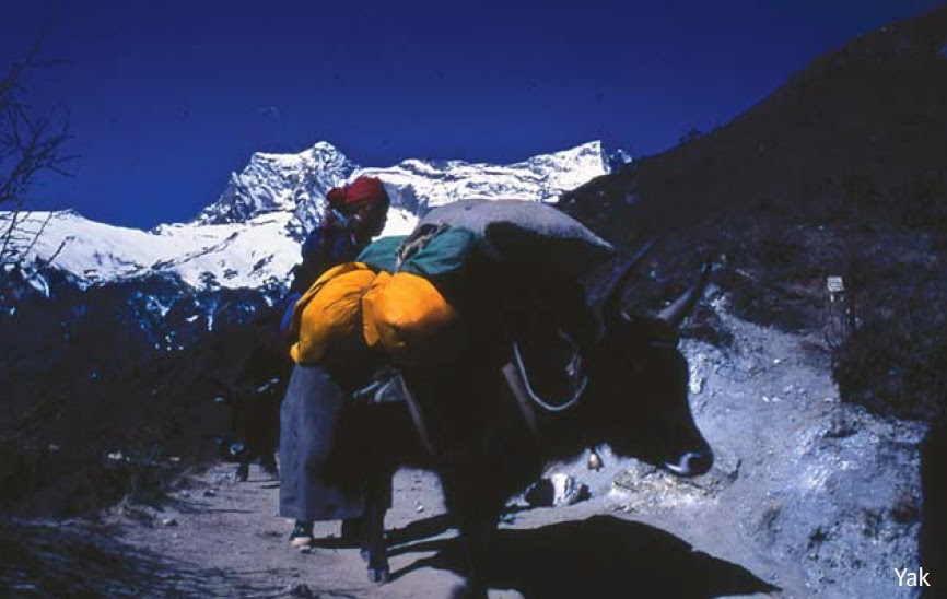
 Pakistan). It lies 128 km east of verest. The western face lies in Nepal while the other side lies in the state of Sikkim, India. 
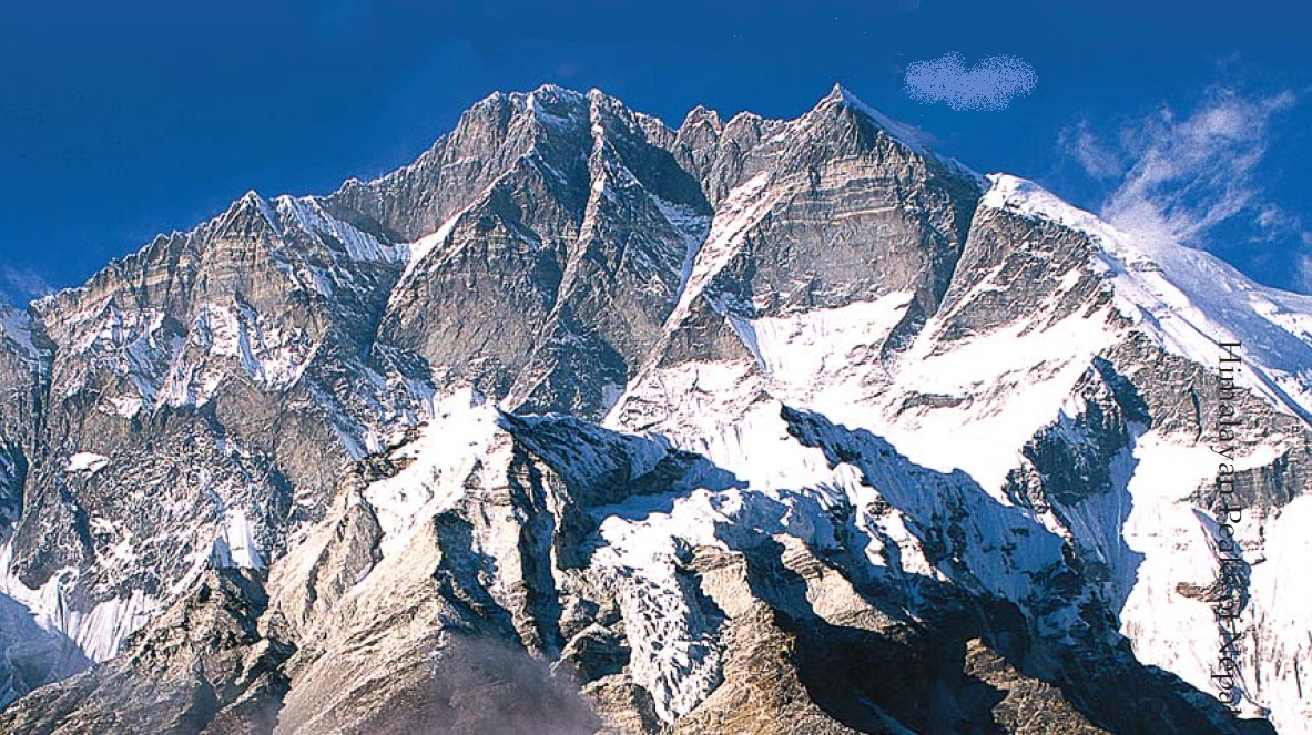
Kanchenjunga or angchenzonga in Sikkimese means “Five treasures of the Great Snows” as the mountain has five prominent eaks. They are Kanchenjunga main (8,586m), Yalung Kang (8,505m), Kanchenjunga West (8,420m), and the Twin Peaks (both 8,476m). Unlike most of the other Himalayan peaks, this mountain lies north to south and the Kanchenjunga glacier drains into the Tamur River which is a tributary of the Koshi.
Climbing Kanchenjunga had been contemplated by many as far back as in 1882, yet no attempt was made until 1905. The first to go up the Yalung glacier was Alaister Crowley but he lost four men on the mountain; a Lieutenant Pache and three porters. For fifteen years, no one dared another attempt.  In 1929, an American climber named Francis Farmer left behind his porters and climbed up the south face but was never seen again. Then Paul Bauer led a Bavarian expedition up the mountain later in the same year and reached the altitude of 7,700m. Following an unsuccessful attempt by Gunther Dyhrenfurth in 1930, Bauer made a second attempt in 1931. Hans Hartman and Dr. Karl Wien reached 7,990m before they were forced to turn back.
With the outbreak of the Second World-War, there was no climbing in the Himalayas. The next attempt was made by Gilmour Lewis and George Frey in 1951 looking for an easier route to the top. He failed and returned two years later with John Kempe but met with no success. He returned once again in 1954 with a new team of climbers but luck was not on his side.
Fifty years after the first attempt, in 1955, a British expedition took off, led by Charles Evans, who had been a member of the successful expedition on Everest two years earlier. Two Britons, George Band and Joe Brown finally made it to thesummit of this difficult mountain. Given the fact that the Sikkimese consideredthe mountain very sacred, the summiteers refrained from stepping right up to the top. They stopped five vertical feet below the summit on 25th May. Finally, Kanchenjunga, the third highest mountain in the world had been conquered. The first Nepali to climb this peak was Ang Phurba Sherpa on 14th May 1980.

Wednesday, September 21, 2011

Mountains of Nepal

Mt. Everest ( 8848 m )
Ever since the highest peak in the world was identified by an employee of the Geological Survey of India in 1852, the mountain has fascinated and drawn climbers from around the world. Known simply as Peak XV when the historic discovery was made, it was eventually named ‘Everest’ by the then Surveyor General, Andrew Waugh in honour of his predecessor, George Everest. The Tibetans and Sherpas (who lived close to the mountain) knew it as Chhomolungma and the Nepalese Government later gave it the name ‘Sagarmatha’. The early climbers like the famous duo, George Mallory and Andrew Irvine attempted to climb from the Tibetan side which lies on the northern side of Everest.